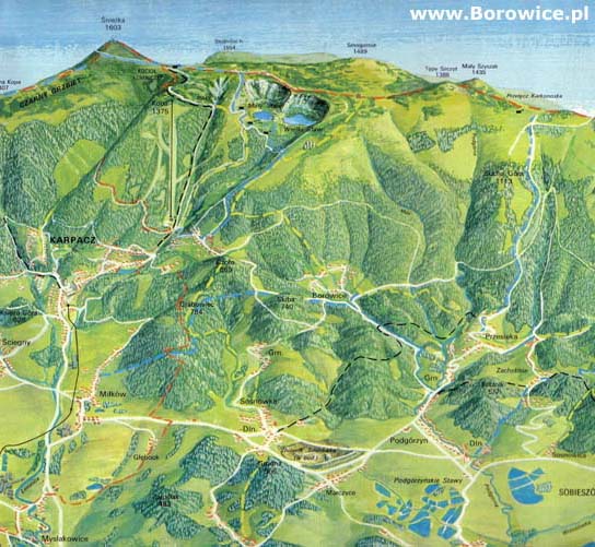
Geography
The Plateau of Karkonosze runs from the area of Lower Szklarska Poręba, through Zachełmie to Miłków. It is separated from the Karkonosze Mountains with a series of valley-like abasements (Michałowice, Jagniątków, Przesieka, Borowice) disjoined by hills and saddles. This area is called the Mountainous Valley of Karkonosze
the Mountainous Valley of Karkonosze (Karkonoski Padół Śródgórski).
Borowice are situated on
the Plateau of Karkonosze between Przesieka and Upper Karpacz, in
the Valley of Five Streams (previously: the Fir Valley). The five streams are (from the western side):
Granicznik,
Borówka,
Modrzyk,
Jodłówka, and
Jeleni Potok, which drift from the mountains and, on the area of the village, join to form
the Kacza River. On the area of Borowice there are several other streams. Next to the yellow track, merely 700 meters from the road there is a charming, small
Jodłówka Waterfall. 2 kilometers from the village there is also a beautiful valley with
the Cascades of the Myja Rive.
 Położenie Borowic w Karkonoszach i szlaki turystyczne w okolicy
Borowice are surrounded by hills covered with a spruce forest. The hills are:
Wierzchnica 649 m n.p.m.,
Młynarz 675 m,
Skiba 740 m,
Wilczak 707 m /
Czoło 874 m,
Jeleniec 905 m /
Czarna Góra 945 m,
Grzbiet Śląski (the main range of the Karkonosze Mountains) with
Smogornia 1490 m,
Słonecznik 1423 m,
Pielgrzymy (the Pilgrims) 1204 m and
Susz 708 m. The surrounding layer of forests is from few to about a dozen kilometers wide.
Not far away from the village there are numerous and very interesting rocks. Some of them had the status of Special Protection and Preservation Objects already before the World War II. They were:
Borowickie Skałki,
Jeleniec,
Koleba,
Szwedzkie Skały (Sweedish Rocks), and
Zamczysko (the Castle). ). Apart from these there are also very interesting erratic rocks and stones like
Zamkowe Skały (the Castle Rocks) or
Słup (the Pile).
Borowice are located at the height of 625 to 710 MSL
Bearings: N 50°47'30" E 15°41'30".
Military bearings from the map no. 461.44: 529,75 634,34.
The area of the village is equal to 816 ha. The majority, 698 ha, is occupied by forests, while fallow lands take 106 ha. Nowadays agriculture does not play a significant role in the economy of the village. Merely a few houses can be called homesteads. Hardly anyone cuts the grass for hey, herds cattle or raises other house animals. It is enough to look at old photographs with panorama to realise that the whole Valley of Five Streams has been overgrown by weeds. Nowadays, vast majority of houses is devoted to tourism. Some of them are guest houses. There is a shop, café and a bar. On the area of the village there is no industrial, nor craft bet. A few houses are inhibited by artists who had, most probably, found inspiration here.
Car distances and approximated ride times
|
| Polska | Odległość | Czas |
| Wrocław | 120 km | 1,5 h |
| Poznań | 300 km | 4 h |
| Kraków | 380 km | 5 h |
| Warszawa | 450 km | 6 h |
| | | |
| Czechy | Odległość | Czas |
| Czechy | | |
| Hradec Kralove | 120 km | 1,5 h |
| Praga | 160 km | 2 h |
| Ostrawa | 230 km | 3 h |
| Brno | 300 km | 4 h |
| | | |
| Niemcy | Odległość | Czas |
| Drezno | 157 km | 2 h |
| Lipsk | 286 km | 3 h |
| Berlin | 296 km | 4 h |
| Hamburg | 563 km | 6 h |
| Frankfurt/M. | 654 km | 7 h |
| Monachium | 659 km | 7 h |
| Dortmund | 696 km | 8 h |
| Mannheim | 710 km | 8 h |
 Contact us